___________
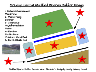
The following diagrams are examples of the proposed
MOhemp Hazmat 5 stage phytoremediation treatment train
This couples the benefits of low cost
phytoremediation and phytoextraction techniques for the Westlake Landfill and Coldwater Creek areas to naturally remove hazmat soil contaminants.
Field Phytoremediation Layout Diagrams
 |
| MOhemp Hazmat Phytoremediation Diagram Field Layout Treatment Train |
Hillside and Low Slope Diagrams
 |
| MOhemp Hazmat Diagram Modified Riparian Buffer Design with Containment Membrane |
 |
| MOhemp Hazmat Phytoremediation Riparian Buffer Diagram |
 |
| MOhemp Hazmat Sketch Phytoremediation 5 Stage Treatment Train |
The landfill is divided into multiple sectors, within which are two operable units (OU), OU-1 and OU-2. In addition to the radioactivity from the dumped barium sulfate cake, soil samples also indicate the presence of many more radioactive materials, including uranium, thorium, and elements resulting from their decay.
![By Debbie Kring (Environmental Protection Agency) [Public domain], via Wikimedia Commons](https://lh3.googleusercontent.com/dcUSZpwd3UhjfeJZ00YQWRc0dTUTuWkOZPfeZeIRXLmsQjph7ZV_4_WqmFO3O01kgSKJ-iZM33SBoH9SPQvuZIQfOp4_fNVXBrLKvQqF-ymmDUZNLZwSq0mB5cS7hlZbEqqUCOGY) |
| By Debbie Kring (Environmental Protection Agency) [Public domain], via Wikimedia Commons |
OU-2 covers 8,700 cubic yards (6,700 m3) on the surface and 109,000 cubic yards (83,000 m3) subsurface
 |
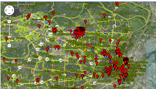
| Coldwater Creek FUSRAP Map Toxic Storage Areas |


